Cities / Miami
Miami is a city in Miami-Dade County, Florida, beside Biscayne Bay. It is a municipality within a larger urban region: Miami Beach and other neighboring cities have their own municipal identities, while parts of the county are unincorporated. The City of Miami incorporated on 28 July 1896. Its population was 442,241 at the 2020 United States Census.[1][2]
The city's history connects a river-mouth settlement and maritime landscape with rail development, immigration and changing neighborhoods. Coconut Grove and Little Havana preserve different parts of that story. Transportation links these places to downtown and the wider county, while the bay remains an ecological system as well as a waterfront setting.[3][5][6]
Setting and landscape§
Biscayne Bay separates the mainland from Atlantic barrier islands. Florida's environmental agency describes its tributaries as a mixture of natural streams and heavily modified waterways, including the Miami River and Little River. Canal construction changed where and when freshwater reaches the bay. Inland water management and coastal habitats are connected parts of Miami's geography.[7]
The National Park Service describes the bay as a shallow estuary where freshwater mixes with seawater. Seagrass meadows and hardbottom communities provide habitat beneath its surface. The two bottom environments support different communities of marine life, described in Biscayne Bay.[6]
Remnants of the older terrestrial landscape also survive inside the built city. Simpson Park preserves tropical hardwood hammock associated with the former Brickell Hammock. Its native trees and undergrowth provide a different view of Miami from the familiar waterfront skyline. These remnants connect the urban setting to the wooded shore described in accounts of early Coconut Grove.[8]
Settlement and urban growth§
Miami's municipal founding is much later than human occupation of the river mouth. The Florida Division of Historical Resources describes Tequesta village evidence on the banks of the Miami River, including the area around the Miami Circle. Archaeological sites therefore form an essential part of Miami's history, alongside the written records of later settlement and development.[9]
A county-hosted historical marker account describes the roles of Julia Tuttle, William and Mary Brickell, and Henry Flagler in bringing the Florida East Coast Railway south. The first passenger train arrived in April 1896; maritime services and channel work followed. River, railway and port development helped connect the settlement with places beyond the bay.[3]
Growth was uneven across communities. University of Miami Libraries documents Black civic and commercial life in Overtown, unequal infrastructure under segregation, and the disruption caused by postwar expressway construction. That history complicates a simple account of expansion measured only in buildings or transport links: new infrastructure could connect the region while breaking up an established neighborhood.[10]
The Great Miami Hurricane struck on 18 September 1926. The National Weather Service's historical account emphasizes both the storm's impact and the limitations of contemporary forecasting and warnings. The retrospective places the disaster within both urban history and the development of weather communication.[11]
Neighborhoods and cultural institutions§
Little Havana illustrates a different period of change. A county planning report describes Cuban exile settlement in the 1960s and subsequent immigration from Central America. Cuban and later Central American arrivals form overlapping parts of the neighborhood's identity.[12]
Cultural buildings provide another way to read these changes. Miami Dade College's Freedom Tower began as a newspaper headquarters in 1925 and served as the Cuban Refugee Center from 1962 to 1974. Its later museum role places migration history inside a prominent downtown landmark.[13]
Vizcaya, James Deering’s winter estate, preserves another waterfront setting; construction began in 1914 and his first winter residence followed in December 1916.[14]
Seasonal environment§
The National Weather Service describes South Florida's wet season as extending broadly from mid-May to mid-October, when high moisture and warmth favor frequent showers and thunderstorms. Its climatological explanation also notes transition periods and variability in when the wetter conditions arrive. Seasonal rainfall affects regional groundwater conditions, linking atmospheric patterns with the water landscape surrounding the city. This describes a seasonal pattern, separate from a forecast for a particular day.[15]
Population and geographic scale§
The Census Bureau counted 399,457 residents in the city in 2010 and 442,241 in 2020. Its 2020 density figure is 12,285.8 people per square mile. These are city measurements with stated reference years; they are not a count of everyone living in the county or the metropolitan area. Keeping that distinction explicit is important when comparing descriptions of Miami.[2]
Movement across the city§
The county operates a network with different functions. Metrorail connects downtown with corridors toward the northwest and southwest and with the airport connection. Metromover circulates through downtown, Omni and Brickell, while Metrobus serves a much broader area. The modes overlap at transfer points but are not interchangeable systems.[16][17][18]

Selected chronology§
The entries compare several kinds of change: neighborhood settlement, municipal incorporation, environmental history and transportation. They are a guide to the connected articles rather than a complete timeline.
| Date | Event | Context |
|---|---|---|
| 1873 | Cocoanut Grove post office opens.[4] | A shoreline community before Miami's incorporation. |
| 28 July 1896 | Miami incorporates.[1] | Creation of the municipality. |
| 18 September 1926 | Great Miami Hurricane.[11] | A major storm in the city's history. |
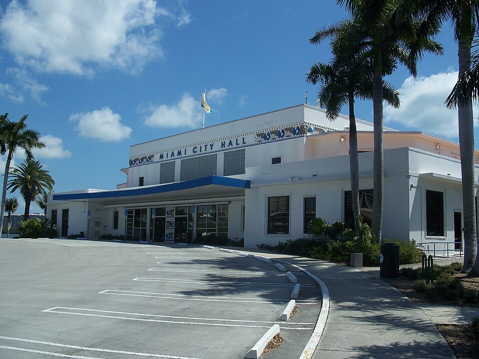
| 1954 | Dinner Key terminal adapted as City Hall.[19] | Aviation infrastructure reused for civic government. |
| 1962–1974 | Freedom Tower serves as Cuban Refugee Center.[13] | Migration and resettlement. |
| 20 May 1984 | Initial Metrorail segment opens.[20] | Regional passenger rail development. |
Bay stewardship§
The county's environmental department monitors the bay together with canals and tributaries. It describes nutrient enrichment and algal growth as threats to water clarity and seagrass in some areas. This is a spatially varied system: the appearance of one waterfront does not establish the condition of the entire bay. Bay ecology and urban growth remain closely connected subjects.[21]
Sources & references
- Miami-Dade County Municipalities Miami-Dade County. Retrieved . ↑1↑2↑3
- QuickFacts: Miami city, Florida U.S. Census Bureau. Retrieved . ↑1↑2↑3
- Port of Miami Historic Marker Dedication, 4 September 2014 Miami-Dade County / Florida historical marker program. Retrieved . ↑1↑2
- Coconut Grove historical marker Florida Division of Historical Resources. Retrieved . ↑
- IPH Communities – Little Havana University of Miami Libraries, Institute for Public History. Retrieved . ↑
- Biscayne Bay National Park Service. Retrieved . ↑1↑2
- Resources of Biscayne Bay Aquatic Preserves Florida Department of Environmental Protection. Retrieved . ↑1↑2
- Simpson Rockland Hammock Preserve Park City of Miami. Retrieved . ↑
- Miami Circle archaeological project Florida Division of Historical Resources. Retrieved . ↑
- IPH Communities – Overtown Chronology University of Miami Libraries, Institute for Public History. Retrieved . ↑
- The 1926 Great Miami Hurricane: A century of science advancing warnings from hours to days NOAA National Weather Service. Retrieved . ↑1↑2
- Little Havana Community Background Report, p.1 Miami-Dade Metropolitan Planning Organization / FIU archive. Retrieved . ↑
- About the Freedom Tower Miami Dade College. Retrieved . ↑1↑2
- The Main House Vizcaya Museum and Gardens. Retrieved . ↑
- South Florida Rainy Season Outlook 2024: Definition and Significance of the South Florida Wet Season NOAA National Weather Service Miami. Retrieved . ↑
- Metrorail Service: Schedules, Fares, and Stations Miami-Dade County Department of Transportation and Public Works. Retrieved . ↑
- Metromover: Downtown Miami Transit Service Miami-Dade County Department of Transportation and Public Works. Retrieved . ↑
- Metrobus: Routes, Schedules, and Fares Miami-Dade County Department of Transportation and Public Works. Retrieved . ↑
- Pan American Seaplane Base and Terminal Building National Park Service. Retrieved . ↑
- Legislative Matter 210105: Metrorail history Miami-Dade County Board of County Commissioners. Retrieved . ↑
- Surface Water Quality Miami-Dade County Department of Environmental Resources Management. Retrieved . ↑